Thank you so much for taking the time to read this blog and enjoy the pictures. The postings are in daily sequence with oldest posts at the bottom and also accessible using the links to the right of the page. If you choose to read the entire thing, please do start at the bottom and work your way up so as to get a good feel for how the days progressed and the adventures unfolded.
For the posts with photos the captions are under the photos. Please click on the photo to enlarge them and if there are any that you particularly like, please feel free to save them to your computer. In order to do so, first click on the photos to expand and then save so that you get the high resolution version.
Again, thanks for visiting and I hope you enjoy your stay!
Sunday, September 9, 2007
Day Ten – The Long Road Home
Answering the call of the road is something I do as naturally as a flower opens to welcome the rays of the rising sun. Once it is in you, it is something you cannot resist. When that beckoning hand of the horizon bubbles through the nonsense of the day-to-day it is a thing of no small wonder to be able to throw a leg over the saddle and point the front wheel in the direction of the evening stable that the sun calls its setting home.
Today is the last day on the road on this installment of my exploration of this great land and it finds me in Iowa City. An unscheduled stop that is the result of my exuberant exercise of the phenomenal amount of power available under my right hand as I took the opportunity to wring every last ounce of horsepower out of the willing engine of my steed in the plains and valleys of Montana. The rear tire was worn to the wires and with the help of my Cleveland dealership, I found and made a service appointment at Gina’s BMW Motorcycles in Iowa City for a set of new tires.
I am a morning person and when I am on vacation I am normally on the road or up and mixed up in some activity at the crack of dawn; you only have so many days away from the desk to enjoy and I like to make the best and most of each one! With my appointment set for 11:00 am, all I could do all morning was wait. For a morning person who normally has several hundred miles of riding done by that time, sitting around in a hotel room for those few hours was an almost exquisite form of torture!
I was so thankful to have my computer and an internet connection but by 7:00 I had read every news story that was of any interest to me, checked the weather in a dozen cities along my intended route several times and made an exhaustive study of the radar images and weather forecasts of a number of sites. And, I still had four hours to kill!! I thought about riding around and exploring the city but that was out of the question as I didn’t know how many miles I had left on the tire before it gave up the ghost and my preference was to use them driving the ten miles to Gina’s.
I flipped through the TV channels and there truly is absolutely nothing on there that is even remotely of any interest to me ......... 7:05 ........ 3 hours and 55 minutes left.
I arranged my stuff really slowly, took a really long shower and then went to the lobby to get a couple of bowls of cereal and a bagel. Back in the room I took my time packing everything back into the bags and then loaded the bike. I managed to make all that last a couple of hours. I was out of there by 9:30 and at Gina’s an hour early. Gina herself was at the counter, she welcomed me with a warm smile and a hearty handshake and she quickly had someone helping me.
Just like my dealer here in Cleveland, they were very friendly and got my bike in line for service at the appointed time. I unloaded the bags so that they mechanic would not have to fuss with them and then poked around the showroom. I spent some time chatting with Woody the salesman who showed me a BMW GS that is now on my mind. I really do not need two bikes but I am thinking about it!
I talked to a guy who has a condo in Breckenridge Colorado and keeps a GS there and has a BMW GT for tooling around Iowa City. He was having new tires put on his GT and we chatted about both bikes and the strengths each has.
There was a fellow there from some place in the middle of Nebraska, west of Omaha and north of nowhere. He had his bike in for new shocks. He rode a GS and his had over 130,000 miles on it. The GS has the same motor as my RT so I spent a lot of time talking to him, hearing about his adventures and also talking about the motor on his bike, the kind of oil he put in it and how he maintains it. He has had no problems with it and with all those miles had not yet opened the engine up for any major service! He said the engine felt and sounded broken in at around 80,000 miles so I had a while yet to go on mine.
There were a few more riders who had come in to kill some time and we variously chatted about adventures on the road and close calls with deer and other road hazards.
My bike was soon ready and by 12:30 I was on the road. Less than an hour later I stopped in Davenport Iowa for lunch at Cracker Barrel. I did not have coffee with lunch as I wanted to save that for later but after half an hour on the road I had to pull over at a BP station to get a cup of java for the afternoon. With that I was back in the groove and headed for Chicago. As I was passing through the several exits near Joliet I saw a couple of custom V-twins, their riders sporting tee shirts and bandanas. One of them was a considerably proportioned and generously bejowled woman whose ample chins and cheeks were fluttering and flapping in the fierce sixty-mile-per-hour hurricane created by her beautiful motorcycle. Each has their own way of enjoying time on two wheels and, waving to them as I passed, I was thankful for my helmet upon hearing the sound of a large insect splatter against and add to the smeared decorations so many other bugs have created on the outer shell of my brain bucket.
It was beautiful blue skies all the way to Indiana when the sun started it’s final descent towards the western horizon and the skies lowered with gray clouds threatening rain. I stopped at the first rest area on the Indiana Turnpike and donned my rain gear. Good thing too, because it rained all the way to Cleveland!
The eastern part of northern Indiana is so infested with deer that they have an electro-mechanical system for alerting drivers to the presence of deer in the vicinity of the road. They have half mile beams similar to the safety-stop ones that are used on modern garage doors so when the beam is broken, rather than activating the stop switch on a garage door, it activates an on switch for a flashing light. One such light flashed as I approached and, sure enough, there were the two blinking reflectors of deer eyes in a pensive furry head on the right side of the road. I braked hard and swerved to the left lane in order to give myself more margin should it decide to bolt across the road. It stayed put and continued on my way.
I stopped somewhere near Toledo on the Ohio Turnpike to fill up the bike and grab a bite to eat. When I was done I moved back under the shelter that covers the pumps at the filling station to gather myself for the remaining couple of hours in the rain. A black Chevrolet Suburban pulled up and a man with military-style close-cropped hair rolled down his window and asked me if I knew where Canton, Ohio was and if he was headed in the right direction. I considered for a second, taking in the woman in the front seat, the kids in the back and the luggage behind them and then beckoned him out of the car to look at my map. I showed him where we were and where he needed to go and also how to read the turnpike ticket so that he would know the exit number he needed to take in order to get on I-77 south to Canton.
He said he had come down from Ann Arbor on I-75 (he would have shortened his trip by about thirty miles if he had taken route 23) and asked where Ann Arbor was on the map. I told him it was off the map as what I was showing him was a map of northern Ohio. That did not seem to register, it was as if the map was just a pretty piece of paper with a bunch of colored lines on it, and he asked me, again, how he would know where to get off the Turnpike for the road to Canton. I explained again and he thanked me, getting back in his SUV. As he buckled his belt, he turned to thank me one more time and I put up my first finger indicating he should wait for something, which he did. I fished around in my tank bag and pulled out my map of Ohio and handed it to him. He was very grateful and they pulled off to the side to consult the map as I was putting my helmet on.
I smiled in wonder. How does a grown man take with a car full of family find himself on the road in the middle of the night, it was about 10:30, and, a dark and stormy night at that, with no clue of where he is or how to get where they were going? It is one thing to look for adventure but it is totally another thing to get on the road clueless when you do have an intended destination and others relying on you. Oh well, his problem and not mine; I simply have to buy another map and he somehow has to figure out how to get to Canton!
The rest of the drive was uneventful and I arrived home after midnight safe and in one piece. What an adventure it has been! I already have three days of my next one partially planned :)
Friday, September 7, 2007
Day Nine – Corn and Beans
I got a good night of sleep and was ready for the road bright and early. The wheels were on the interstate at 4:30 pointed east; toward the plains and away from those awesomely beautiful mountains.
The first part of the ride was under a crescent moon hanging beautifully in the eastern sky surrounded by constellations I have not the knowledge to name but the capacity to appreciate. Dark as it was out here without the light pollution of urban areas there were not as many stars as I expected to see on a clear night without much illumination from the moon.
I started out in a state of extremely high alert after my encounter with a deer the prior night. After an hour on the road I began to relax, figuring that there really should be no deer issues out here on the plains. Though I was relaxed, my eyes were still taking in whatever the beam of the headlights presented and I saw, off to the right hand side, two round reflectors that were not in line with the others on the road. A second later, the headlights revealed a buck on the side of the road.
Yeah, I know the drill, apply full brakes and keep your eye on the critter. Luckily, it did not move so there was no incident to recount on that encounter.
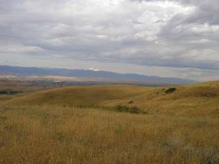
The sun came up soon after that to reveal a countryside devoid of anything that would be of interest to anyone other than a botanist specializing in prairie grasses. I have said that Kansas west of Salina has absolutely nothing to look at as you drive through. Well, the drive through the southern part of South Dakota has even less! Before you get to the Missouri River, there is nothing but grass. No farms, no houses, no crops, just grass, not even the dot of a solitary cow punctuating a distant hillock.
I ran through my first tank of gas and stopped just after crossing the Missouri and filled both the bike and my belly. I was soon back on the road and the scenery changed from grass to a few farms with either corn or beans. The population of both animals and people rose evidenced by the increasing number of homesteads – speaking of homesteads, I drove by the home town of Laura Ingells-Wilder from Little House on the Prairie! – and acreage under crop. The variety, though, did not change from corn and beans!
On into Minnesota, and it was pretty much the same – corn and soy beans. The one cool thing in Minnesota was the electricity windmill farms. It is windy as hell out there and they make good use of that renewable resource.
I got gas again in Minnesota, enough to get me half way through Iowa. Ah, Iowa, more corn and beans! I was making great time and feeling wonderful so my plan was to get gas, eat and then think about canceling my hotel in South Bend, Indiana and driving on to Cleveland tonight. However, I went into the gas station to use their bathroom and when I came out I noticed the rear tire was worn down to the wires around probably two thirds of its circumference. I wondered if I could limp it back home but home was still over six hundred miles away. I then wondered if I could limp it to South Bend, Indiana where I was booked for the night and then figure out how to get it home.
That too was not a good idea because I ran the risk of catastrophic tire failure and, being in no mood for a catastrophe, I called Michelle, my travel agent and asked her to cancel the hotel in South Bend and find me something in Iowa. I told her that I also wanted her to check out the BMW website to see if there were any dealerships in Iowa. When I hung up with her I called my dealer to see if they could find out for me and they did find a dealer in Iowa City, about 50 miles further down my route. I thanked them and called the dealer to find out if their service department was open on Saturday and if they could get me in for a set of tires. The answer to both was yes but the appointment was at 11:00 am. Well, when you are the mercy of others, you are at the mercy of others so 11:00 am it is.
This set has less miles on it than the last set of the same brand and I wondered why the tire was worn through two thousand miles shy of the mark the other one hit. Then I remembered that I spent a day and a half wringing every available ounce of horsepower out of that motor. There is a price to be paid for fun and the currency for this version was rubber from the tire. It takes quite a bit of horse power, 110 in this case, to propel the bike to the speeds I reached and sustained in Montana but that power has to be delivered to the road and with a contact patch smaller than a deck of cards I was shredding a small layer with each full power exit from the hundreds of sweeping turns I enjoyed.
I called Michelle back and she found me a hotel in Iowa City, provided the directions and wished me well. What a woman!! She was there in a moment of need and came through! I’m telling you, if you want a really good travel agent, click on the link at the top right of this page and call her.
I arrived at the hotel and waited my turn in line as the woman in front of me told the clerk that she deserved the Mother-of-the-Year award for driving her daughter from Chicago to Iowa City so that she could see her boyfriend for one night.
There is a restaurant/bar attached to the hotel so after I got myself situated I wandered over there and had dinner. When I was done and about to leave the Mother-of-the-Year lady came into the restaurant, recognized me from the check-in, came over to chat. It was a wonderful conversation that covered so many topics and it was quite delightful to spend the evening just yacking away. We ended up talking through a few rounds but could not get the problems of the world solved so we called it a night.
Now I need to pull up directions from here to the dealer who will replace my tires tomorrow. Hopefully they can get it done pretty quickly and I can get on the road. I have between eight to ten hours on the road to get home and I don’t get to leave in the morning as I normally would so my arrival will be sometime late in the evening as opposed to the late morning arrival I had planned and expected.
Oh well, none of us has a crystal ball and we cannot see what the day brings. Best thing to do is take it as it comes.
The first part of the ride was under a crescent moon hanging beautifully in the eastern sky surrounded by constellations I have not the knowledge to name but the capacity to appreciate. Dark as it was out here without the light pollution of urban areas there were not as many stars as I expected to see on a clear night without much illumination from the moon.
I started out in a state of extremely high alert after my encounter with a deer the prior night. After an hour on the road I began to relax, figuring that there really should be no deer issues out here on the plains. Though I was relaxed, my eyes were still taking in whatever the beam of the headlights presented and I saw, off to the right hand side, two round reflectors that were not in line with the others on the road. A second later, the headlights revealed a buck on the side of the road.
Yeah, I know the drill, apply full brakes and keep your eye on the critter. Luckily, it did not move so there was no incident to recount on that encounter.
The sun came up soon after that to reveal a countryside devoid of anything that would be of interest to anyone other than a botanist specializing in prairie grasses. I have said that Kansas west of Salina has absolutely nothing to look at as you drive through. Well, the drive through the southern part of South Dakota has even less! Before you get to the Missouri River, there is nothing but grass. No farms, no houses, no crops, just grass, not even the dot of a solitary cow punctuating a distant hillock.
I ran through my first tank of gas and stopped just after crossing the Missouri and filled both the bike and my belly. I was soon back on the road and the scenery changed from grass to a few farms with either corn or beans. The population of both animals and people rose evidenced by the increasing number of homesteads – speaking of homesteads, I drove by the home town of Laura Ingells-Wilder from Little House on the Prairie! – and acreage under crop. The variety, though, did not change from corn and beans!
On into Minnesota, and it was pretty much the same – corn and soy beans. The one cool thing in Minnesota was the electricity windmill farms. It is windy as hell out there and they make good use of that renewable resource.
I got gas again in Minnesota, enough to get me half way through Iowa. Ah, Iowa, more corn and beans! I was making great time and feeling wonderful so my plan was to get gas, eat and then think about canceling my hotel in South Bend, Indiana and driving on to Cleveland tonight. However, I went into the gas station to use their bathroom and when I came out I noticed the rear tire was worn down to the wires around probably two thirds of its circumference. I wondered if I could limp it back home but home was still over six hundred miles away. I then wondered if I could limp it to South Bend, Indiana where I was booked for the night and then figure out how to get it home.
That too was not a good idea because I ran the risk of catastrophic tire failure and, being in no mood for a catastrophe, I called Michelle, my travel agent and asked her to cancel the hotel in South Bend and find me something in Iowa. I told her that I also wanted her to check out the BMW website to see if there were any dealerships in Iowa. When I hung up with her I called my dealer to see if they could find out for me and they did find a dealer in Iowa City, about 50 miles further down my route. I thanked them and called the dealer to find out if their service department was open on Saturday and if they could get me in for a set of tires. The answer to both was yes but the appointment was at 11:00 am. Well, when you are the mercy of others, you are at the mercy of others so 11:00 am it is.
This set has less miles on it than the last set of the same brand and I wondered why the tire was worn through two thousand miles shy of the mark the other one hit. Then I remembered that I spent a day and a half wringing every available ounce of horsepower out of that motor. There is a price to be paid for fun and the currency for this version was rubber from the tire. It takes quite a bit of horse power, 110 in this case, to propel the bike to the speeds I reached and sustained in Montana but that power has to be delivered to the road and with a contact patch smaller than a deck of cards I was shredding a small layer with each full power exit from the hundreds of sweeping turns I enjoyed.
I called Michelle back and she found me a hotel in Iowa City, provided the directions and wished me well. What a woman!! She was there in a moment of need and came through! I’m telling you, if you want a really good travel agent, click on the link at the top right of this page and call her.
I arrived at the hotel and waited my turn in line as the woman in front of me told the clerk that she deserved the Mother-of-the-Year award for driving her daughter from Chicago to Iowa City so that she could see her boyfriend for one night.
There is a restaurant/bar attached to the hotel so after I got myself situated I wandered over there and had dinner. When I was done and about to leave the Mother-of-the-Year lady came into the restaurant, recognized me from the check-in, came over to chat. It was a wonderful conversation that covered so many topics and it was quite delightful to spend the evening just yacking away. We ended up talking through a few rounds but could not get the problems of the world solved so we called it a night.
Now I need to pull up directions from here to the dealer who will replace my tires tomorrow. Hopefully they can get it done pretty quickly and I can get on the road. I have between eight to ten hours on the road to get home and I don’t get to leave in the morning as I normally would so my arrival will be sometime late in the evening as opposed to the late morning arrival I had planned and expected.
Oh well, none of us has a crystal ball and we cannot see what the day brings. Best thing to do is take it as it comes.
Thursday, September 6, 2007
Day Eight - Black Hills
Please click on the pictures to enlarge. The captions are below the pictures. Please feel free to keep any you like but before you do remember to enlarge the image so that you save the high resolution version.
Today was planned as a short day. It was a day to see the Black Hills of South Dakota and then rest up for the crossing of the plains. Knowing I would not be on the road for very long, I didn’t leave until close to 8:00 am. I really don’t like leaving the mountains behind and, as always, the morning of my departure placed me on a route that laid the plains out before me and the mountains in my mirrors. This morning I rode south on I-90 for about 40 miles with a spectacular view of the Big Horn Mountains to west and the rolling plains to the east. I stopped at a small scenic pull-out to photograph the mountains and see what I missed when I drove in last night under the cover of darkness. Golden plains leading to lush green foothills which gave way to blue and purple mountains. The highest peak was hidden in the clouds but beneath it, the range spread as far north as I could see and about fifty or sixty miles to the south. I stood, taking it in for a few minutes and had to tear myself away. I didn’t want to leave, I wanted to turn my motorcycle back west and explore more mountain roads, I wanted to see more of Wyoming and Montana but I knew that the waking nest of the sun was the direction in which I had to point the front wheel and show my back to the mountains that have their tendrils wrapped around my heart. No worry, mountains, if it is in the cards, I will surely be back.
Melodramatic, yes, but, if you have not experienced the mountains with all the beauty, challenges and surprises they yield, then you just don’t know.
 The south end of the Big Horn Mountains as seen from I-90 just south of Sheridan, Wyoming.
 The middle portion of the Big Horn Mountains.
 The northern portion of the Big Horn Mountains.
 The eastern foothills of the Big Horn Mountains.
 A final shot of the mountains. What a trip it has been and what wonder to look forward to as I begin planning for the next trip.
I rode east, glancing back to the mountains every few minutes as they faded into the horizon and in a couple of hours I was in Gillette, Wyoming where I stopped to get breakfast and fill up the bike. From there I headed south on route 58 with the intention of riding through the Thunder Basin National Grassland on my ride into the Black Hills of South Dakota.
Along route 58, before I reached route 450 which would take me to the Black Hills I spotted some bison on a ranch but I was not able to stop. It was cool to see them having traveled hundreds of miles through Montana and Wyoming without setting eyes on even one!
Along route 450 I passed by a huge open faced coal mine which boasted of being the largest surface mine in North America. Given the length of trains on sidings and the couple that were leaving in addition to the gigantic dump trucks I would have no reason not to believe the claim.
 I do like my coloful rocks! This is a formation along route 450 on the way to the Black Hills.
 This formation was across the road from the one above and it too caught my eye.
 What appeared to be a small herd of wild bison in South Dakota. I am guessing they are wild because they are outside the fence in an area that was not identified as "Free Range".
 The walkway leading up to Rushmore.
 The Flag and State corridor.
 The amphitheater at Mt. Rushmore right beneath the busts.
 A close-up shot of the busts.
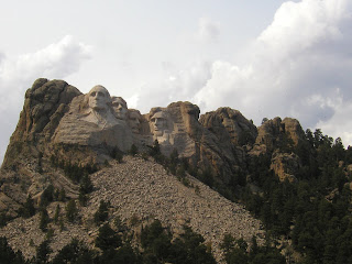 A little longer shot of the busts.
Leaving the Black Hills the western sky looked ominous and a few sprinkles were falling. After my ride in the rain last night I was in no mood to ride in the rain today so I made a beeline for Rapid City with the hope of checking in and unloading the bike before the rain hit. I made it with about ten minutes to spare!
I ate at a close by Indian restaurant and then headed back to the hotel to get the bike ready for the trip tomorrow. The oil level was good and I went around the corner to fill the tank. I was fed, as was the bike and I went inside to get the rest I would need for the thousand-mile trip across the plains to Indiana the next day. The forecast calls for rain at various points along the route and if it does come, I hope it hold none of the drama I experienced with last night’s weather!
Today was planned as a short day. It was a day to see the Black Hills of South Dakota and then rest up for the crossing of the plains. Knowing I would not be on the road for very long, I didn’t leave until close to 8:00 am. I really don’t like leaving the mountains behind and, as always, the morning of my departure placed me on a route that laid the plains out before me and the mountains in my mirrors. This morning I rode south on I-90 for about 40 miles with a spectacular view of the Big Horn Mountains to west and the rolling plains to the east. I stopped at a small scenic pull-out to photograph the mountains and see what I missed when I drove in last night under the cover of darkness. Golden plains leading to lush green foothills which gave way to blue and purple mountains. The highest peak was hidden in the clouds but beneath it, the range spread as far north as I could see and about fifty or sixty miles to the south. I stood, taking it in for a few minutes and had to tear myself away. I didn’t want to leave, I wanted to turn my motorcycle back west and explore more mountain roads, I wanted to see more of Wyoming and Montana but I knew that the waking nest of the sun was the direction in which I had to point the front wheel and show my back to the mountains that have their tendrils wrapped around my heart. No worry, mountains, if it is in the cards, I will surely be back.
Melodramatic, yes, but, if you have not experienced the mountains with all the beauty, challenges and surprises they yield, then you just don’t know.
 The south end of the Big Horn Mountains as seen from I-90 just south of Sheridan, Wyoming.
 The middle portion of the Big Horn Mountains.
 The northern portion of the Big Horn Mountains.
 The eastern foothills of the Big Horn Mountains.
 A final shot of the mountains. What a trip it has been and what wonder to look forward to as I begin planning for the next trip.
I rode east, glancing back to the mountains every few minutes as they faded into the horizon and in a couple of hours I was in Gillette, Wyoming where I stopped to get breakfast and fill up the bike. From there I headed south on route 58 with the intention of riding through the Thunder Basin National Grassland on my ride into the Black Hills of South Dakota.
Along route 58, before I reached route 450 which would take me to the Black Hills I spotted some bison on a ranch but I was not able to stop. It was cool to see them having traveled hundreds of miles through Montana and Wyoming without setting eyes on even one!
Along route 450 I passed by a huge open faced coal mine which boasted of being the largest surface mine in North America. Given the length of trains on sidings and the couple that were leaving in addition to the gigantic dump trucks I would have no reason not to believe the claim.
 I do like my coloful rocks! This is a formation along route 450 on the way to the Black Hills.
 This formation was across the road from the one above and it too caught my eye.
Fifty miles later I crossed the border into South Dakota. The road wound through the western foothills of the Black Hills and when I was about ten miles from Mount Rushmore a small herd of bison caught my eye. They were about a hundred yards back from the paved road and grazing OUTSIDE the fence of some fenced property. I did a quick U-turn and drove down the dirt road until I was probably thirty yards from them. I turned took a couple of shots and then turned the motor cycle to face the road. Leaving it running, I started walking towards the small heard with the hope of getting a closer shot but leaving a decent escape. Not knowing if bison charge and how fast they can run I did not want to venture too close. I know about domestic cattle and know that I can outrun your average bull should they become aggressively excited but I don’t know bison!!
As I approached them, the largest one took notice of me and moved his head in a U pattern while snorting and taking a step towards me. I stopped and contemplated the next move. He could be faking me out which would mean it was safe to move in for a closer shot or he could be nervous and preparing to charge at a potential threat.
I looked at the motorcycle and considered what it would take to jump on, secure the camera, pull up the kick stand, put it in gear and tear out of there without stalling the engine in fear. Seconds piled up. I then considered how long it would take the bull bison to cover that distance and figured that I was close enough with a reasonable margin of safety.
I took my photos and then watched as a small group of horses inside the adjoining field came running across to see what was going on. I told them that the big bison was afraid that little old me was interested in his heard but that he had no worries, I had no interest and he could keep all his heifers to himself.
 What appeared to be a small herd of wild bison in South Dakota. I am guessing they are wild because they are outside the fence in an area that was not identified as "Free Range".
I got back on the bike and headed to Mount Rushmore. For those of you who have not been, this monument is deep in the Black Hills!! When you arrive, though, you are greeted with a multi-lane admission ticket area and then a multi-storey concrete parking garage! There is an impressive granite-paved walk way up to the monument, passing though a corridor of square granite columns with a flag of each state of the union on each face of the columns. The layout is in order of each state’s admission to the union. This promenade is a visual channel to the monument. As you arrive at the end of the corridor you find yourself above the amphitheater with the busts of the founding fathers towering above. It is impressive!
 The walkway leading up to Rushmore.
 The Flag and State corridor.
 The amphitheater at Mt. Rushmore right beneath the busts.
 A close-up shot of the busts.
 A little longer shot of the busts.
Leaving the Black Hills the western sky looked ominous and a few sprinkles were falling. After my ride in the rain last night I was in no mood to ride in the rain today so I made a beeline for Rapid City with the hope of checking in and unloading the bike before the rain hit. I made it with about ten minutes to spare!
I ate at a close by Indian restaurant and then headed back to the hotel to get the bike ready for the trip tomorrow. The oil level was good and I went around the corner to fill the tank. I was fed, as was the bike and I went inside to get the rest I would need for the thousand-mile trip across the plains to Indiana the next day. The forecast calls for rain at various points along the route and if it does come, I hope it hold none of the drama I experienced with last night’s weather!
Day Seven - Bear Tooth
Please click on the photos to enlarge. The captions are below the photos. Feel free to save any you like but be sure to enlarge them first so that you get the high resolution version.
I knew I had a long day ahead of me but I really had no idea just how long the day would turn out to be! The weather forecast called for 50% - 60% chance of rain in the morning and thunder storms in the afternoon in all the towns along my intended route. Also, I was starting out immediately on two-lane roads so I did not want to leave before sunrise.
I did not get out of the hotel until 8:00 am and was out of Great Falls and on the route by 8:30 am. In the low 60’s it was a cool morning but warmer than some on this trip so far. The skies were clear overhead but as I got out of town and back onto the miles and miles and miles of wheat I could see that the distant mountains to the south, east and west were shrouded in clouds and there were also several dark spots to the south and that looked like the rain that had been promised.
As the road opened up so did my right hand. You can go for many, many miles without seeing another car and I think that one of the reasons why the speed limit is really not enforced in Montana is that if a cop sat out on one of the main roads through the state waiting for speeders he might get one in a day as you can see far beyond the range of both laser and radar; a futile and pointless pursuit. Also, the police here do not see themselves as baby sitters. They are there to enforce the law and there are many more important laws to enforce than the speed limit on the open road.
The miles ticked away rapidly as I quickly reeled in the mountains. About 20 miles out of Great Falls I turned south on route 89 in Armington. The road wound down along the Belt River valley so gone were the miles of wheat fields. It is a beautiful valley with nice sweeping turns which allowed me to lean the bike way over as I pulled hard out of turns. I followed the river into the Little Belt Mountains, cresting near Big Baldy Mountain, elevation 9,191 feet and then running back down by Kings Hill at 8,008 feet in elevation. Once out of the Little Belt Mountains it was back to the plains for the rest of the sprint down to I-90. And what a sprint it was! As I approached the freeway the open plains gave me a spectacular view of the north end of the Abasroka Range of mountains. I did not take a photo as the summit was up in the clouds.
These signs are from a scenic stop along the Belt River just south of Armington.


 The Belt River south of Armington.
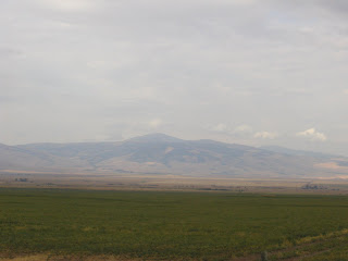 Back on the plains after cresting the Little Belt Mountains. This is a photo of the Big Belt Mountains to the west.
On the freeway I turned east and gassed up about twenty miles on as I had burned through most of the tank. At the gas station I checked the oil and I was down to one third in the little indicator window. For whatever reason the BMW twin engine is designed to consume oil when pushed hard. They have been making this motor for years and I guess in the millions of miles the design has traveled around the world on public roads and on the race track taught them to build it that way. Oh well, all I know is that it works and it works well.
I don’t carry a funnel so I finished up a bag of Planters Trail Mix and fashioned a funnel from it. As I was attending to the bike a woman in her sixties driving a full sized Ford F-150 with Alaska plates and one of those over-sized looking campers that can be carried on a pickup struck up conversation with me. She was a gruff and hard of hearing but it turned out that she calls herself a biker babe as she keeps a small Yamaha 250 in Alaska and a 650 in Arizona. When she is not traveling between the two her primary mode of transportation is either bike. She then went about her business fussing with getting ice in coolers and such. As I was gathering myself for the next leg a tall and weathered looking fellow came and asked about the bike. He was a trucker who said he envied my being able to travel on the bike. He also said that the BMW was the right machine with which to do Montana as the cops had better things to do than mind your speed. I told him that in all the miles I had traveled on Montana roads I has only seen two state troopers and all the other cops I had seen were in the little towns as I passed through. He told me about the days when they did not have a speed limit and if they thought you were over cooking it they would pull you over and give you a ticket and the violation was excessive fuel consumption. I love Montana!
 This colorful rock formation was the gateway to the climb up to Bear Tooth Pass.
The following photos are from Bear Tooth Pass. I don't have a detailed map of the area so I cannot provide the names of peaks, rivers and lakes.
It was a pretty spectacular ride up and the photos below tell the story. Near the top I met and chatted briefly with a group made up of an older couple in their 70’s, he had both hips and one knee replaced but was determined to get out and walk to each view point. They were accompanied by their daughter, who was the one driving them around, and her son who looked to be about 12. They were from Williamsport, Pennsylvania and were traveling the parks in the Rockies. I asked them if they had been to Glacier National Park and they said that was their destination the next day. I recommended that if their schedule allowed they should spend at least a full day. It turns out they planned at least three if not more days in the park. My quizzical look was answered by “We are not going home until December so we will take whatever time we feel we need.” – good for them!!
 This is why we ride mountain roads!
 I climbed up to a jagged point to see what was on the other side. Way down there is my bike and beyond that is Wyoming.
 The northern peaks of Yellowstone National Park as seen on the descent from Bear Tooth Pass.

 The road was closed about a mile further up. What I thought was mist turned out to be smoke from forest fires that forced the closure of the road and lengthened my day.


I was on route 14 and one option was to go back to Graybull, take route 310 up to Alt route 14 which ran north of 14. The two roads meet about ten miles from where I was being forced to turn around and not knowing how far up the road the fire was I didn’t want to risk traveling up Alt 14 only to get to the foot of the mountain after traveling 150 mile only to learn that road too was closed.
So I chose the southern route which would take me through Worland and then east on route 16 over Powder River Pass at 9,666 feet in elevation way up in the Big Horn Mountains. I gassed up AGAIN as I had traveled close to 100 miles and only had about 150 left in the tank and the freeway was about 150 miles away. I did not want to chance it.
Getting out of town and heading south I saw rain in my path. I hoped it was beyond my turning point and I thought I was good until about three miles outside Worland where I ran into the wet stuff. To the east looked clear so I rode through that, passing a dude on a Road King wearing just a tee shirt, jeans and shades. The poor guy was SOAKED!! Sure enough, a couple of miles east of Worland the drops stopped and I started to dry off. After about ten miles I stopped to put on my serious rain gloves – heavy duty black rubber gloved from Home Depot – and as I was doing so I watched the lightening from the storms around light up the sky while I zipped up the vents and closed the rain seals on the jacket.
I was fortunate that though the roads were occasionally wet, I had no rain for the fifty or so miles to the foot of the climb up the Big Horn Mountains. It was now pretty much dark and I had fifty miles to ride through the heavily forested range. About five miles into the climb I noticed the tell-tale blinking reflector of a deer’s eye to the right of the road and in a second the beam of the lights revealed the head of a deer peeking over the guard rail. Brakes full on!! The critter did not jump onto the road and, if she was accompanied by others, they too stayed put. The additionally scary thing about it was this was a section of road with what looked to be a cliff on the left of the road and a drop-off into the river valley on the right where the deer was standing. If there were deer on THAT part of the road, what of the forests and upland meadows ahead?!?! While the speed limit was 65 and I had been tooling along at 5 to 10 over I brought it down to five under!
About three miles up the road the switchbacks started and with them the rain came! This was something I really did not want to do. I don’t mind riding in the rain, actually, I kind of like it but not on twisty back roads and not at night ...... on twisty back roads!!
Anyway, I was now vigilant for slick spots, gravel on the corners and more critters on the move. There was traffic coming in the opposite direction but it seemed I was the only on going east. However, as I neared the summit, I saw headlights fast approaching and I wondered who in the world was out enjoying the curves in this weather. The car slowed as it reached me on a double yellow line and patiently waited as I gingerly made my way along about a mile of curves before the hashed center line indicated a passing zone. It did not pass and I did not want a car behind me in these conditions so I let off the gas, turned my right blinker on and waved it by. It hesitated about half a minute and then whizzed on by. It turned out to be a Wyoming State Police car – I wonder if they do a sweep of the mountain roads in the night to make sure there are no incidents.
I was getting comfortable with the rain and starting to feel better as I was almost half done with the forest. All of a sudden there it was, a huge buck in my headlights. It was not more than 50 yards ahead and that is maximum braking force distance on good roads. I slammed on the brakes and the deer, startled to find a set of bright lights stopped dead in its tracks. As I braked I started to point the bike to the back of the deer but then it made as if to turn back. The yards were closing fast and I hoped it would not jump back because if that was its decision then I could clear its rump at a low speed. If it turned back I guessed impact would be between 10 – 15 MPH and I wondered if I would be able to keep the bike upright. He decided to go forward, jumping off the road in his initial intended direction. I kept up the pressure on the brakes because I figured there would be more and with the way deer run when they are startled my guess was the next one would either jump in front of me or run into the side of me so I prepared to counter steer into the force of side impact so that I could make an attempt to keep the bike on the road if it happened. I passed the crossing point as the buck leapt out of the beam and, thankfully, if there were others with it they delayed their crossing until I was past the path.
I dropped the bike into second gear and putted along for a couple of minutes at about 25 MPH as I gathered myself. This time the adrenaline floodgates were open and my heart was racing and had I been standing I am sure my legs would be shaking!! I wanted to stop but I figured standing around on a dark twisty mountain road in the rain was probably not a safe thing to do.
I got back up to the 45 MPH I had been doing and crossed the pass a few miles further and about five miles on the other side the rain stopped. I only brought the speed up to 60 as I descended to Buffalo (a name more apt for a town in Wyoming than upstate New York) In Buffalo I jumped on the freeway for the 44 mile ride into Sheridan with a few sprinkles here and there and a downpour through the only five miles of construction on this stretch of road – go figure!
I checked in and was thankful to have a great travel agent who, when she made the reservation, had instructed them to give me a ground floor room, instructions which they followed. After unloading I walked across the street to a gas station and bought a pre-wrapped ham and cheese hoagie and a diet Seven Up as they had no beer!!
I should have been in here by 7:00 pm but it was now 10:00 pm. However, I was here and safe so I was happy, tired but happy.
I checked the weather for the next day as I ate and saw that they are calling for rain again. Thankfully, it is a short mileage day and I should be able to make it in before dark. Well, we will see what the day brings!
I knew I had a long day ahead of me but I really had no idea just how long the day would turn out to be! The weather forecast called for 50% - 60% chance of rain in the morning and thunder storms in the afternoon in all the towns along my intended route. Also, I was starting out immediately on two-lane roads so I did not want to leave before sunrise.
I did not get out of the hotel until 8:00 am and was out of Great Falls and on the route by 8:30 am. In the low 60’s it was a cool morning but warmer than some on this trip so far. The skies were clear overhead but as I got out of town and back onto the miles and miles and miles of wheat I could see that the distant mountains to the south, east and west were shrouded in clouds and there were also several dark spots to the south and that looked like the rain that had been promised.
As the road opened up so did my right hand. You can go for many, many miles without seeing another car and I think that one of the reasons why the speed limit is really not enforced in Montana is that if a cop sat out on one of the main roads through the state waiting for speeders he might get one in a day as you can see far beyond the range of both laser and radar; a futile and pointless pursuit. Also, the police here do not see themselves as baby sitters. They are there to enforce the law and there are many more important laws to enforce than the speed limit on the open road.
The miles ticked away rapidly as I quickly reeled in the mountains. About 20 miles out of Great Falls I turned south on route 89 in Armington. The road wound down along the Belt River valley so gone were the miles of wheat fields. It is a beautiful valley with nice sweeping turns which allowed me to lean the bike way over as I pulled hard out of turns. I followed the river into the Little Belt Mountains, cresting near Big Baldy Mountain, elevation 9,191 feet and then running back down by Kings Hill at 8,008 feet in elevation. Once out of the Little Belt Mountains it was back to the plains for the rest of the sprint down to I-90. And what a sprint it was! As I approached the freeway the open plains gave me a spectacular view of the north end of the Abasroka Range of mountains. I did not take a photo as the summit was up in the clouds.
These signs are from a scenic stop along the Belt River just south of Armington.


 The Belt River south of Armington.
 Back on the plains after cresting the Little Belt Mountains. This is a photo of the Big Belt Mountains to the west.
On the freeway I turned east and gassed up about twenty miles on as I had burned through most of the tank. At the gas station I checked the oil and I was down to one third in the little indicator window. For whatever reason the BMW twin engine is designed to consume oil when pushed hard. They have been making this motor for years and I guess in the millions of miles the design has traveled around the world on public roads and on the race track taught them to build it that way. Oh well, all I know is that it works and it works well.
I don’t carry a funnel so I finished up a bag of Planters Trail Mix and fashioned a funnel from it. As I was attending to the bike a woman in her sixties driving a full sized Ford F-150 with Alaska plates and one of those over-sized looking campers that can be carried on a pickup struck up conversation with me. She was a gruff and hard of hearing but it turned out that she calls herself a biker babe as she keeps a small Yamaha 250 in Alaska and a 650 in Arizona. When she is not traveling between the two her primary mode of transportation is either bike. She then went about her business fussing with getting ice in coolers and such. As I was gathering myself for the next leg a tall and weathered looking fellow came and asked about the bike. He was a trucker who said he envied my being able to travel on the bike. He also said that the BMW was the right machine with which to do Montana as the cops had better things to do than mind your speed. I told him that in all the miles I had traveled on Montana roads I has only seen two state troopers and all the other cops I had seen were in the little towns as I passed through. He told me about the days when they did not have a speed limit and if they thought you were over cooking it they would pull you over and give you a ticket and the violation was excessive fuel consumption. I love Montana!
 This hard worker needs some oil!
 A makeshift oil funnel.
I left Big Timber for the quick run to Columbus where I would get off the freeway and back to the two-lanes. Route 78 took me up to Red Lodge, nestled in the northern foot hills of the Bear Tooth Mountains. As I was gassing up (there are no gas stations for the next hundred and fifty miles so up there is not a good place to run dry) a group of Harley Davidson’s pulled in and a couple of the riders came up to check out the bike. They were from Illinois and had come out and rented their bikes to ride through the mountains. Just a couple of guys having a good time! One had a Gold Wing and the other was shopping for a new bike and he said his Gold Wing buddy was pushing him to get a BMW. They asked a bunch of questions about the bike, chatted a little about the roads they had ridden and I asked them if they had ridden my intended route to Sheridan and they had and said I would love it. I asked them if it was raining over the top of Bear Tooth Pass and they said it was cloudy but they had not seen a drop and they wished the same for me. We parted ways, they going north and me heading south up the mountain.
 This colorful rock formation was the gateway to the climb up to Bear Tooth Pass.
The following photos are from Bear Tooth Pass. I don't have a detailed map of the area so I cannot provide the names of peaks, rivers and lakes.
It was a pretty spectacular ride up and the photos below tell the story. Near the top I met and chatted briefly with a group made up of an older couple in their 70’s, he had both hips and one knee replaced but was determined to get out and walk to each view point. They were accompanied by their daughter, who was the one driving them around, and her son who looked to be about 12. They were from Williamsport, Pennsylvania and were traveling the parks in the Rockies. I asked them if they had been to Glacier National Park and they said that was their destination the next day. I recommended that if their schedule allowed they should spend at least a full day. It turns out they planned at least three if not more days in the park. My quizzical look was answered by “We are not going home until December so we will take whatever time we feel we need.” – good for them!!
 A glacial valley

 A glacial lake overlooking a large glacial valley.
 This is why we ride mountain roads!
 Garnder Lake on top of Bear Tooth Pass looking south into Wyoming.


 I climbed up to a jagged point to see what was on the other side. Way down there is my bike and beyond that is Wyoming.
 This was the "path" up and down the jagged peak.
 The road winds down into Wyoming past more glacial lakes. In the winter they close the road as it is under many feet of snow. All these lakes turn to solid ice in the winter and continue their job eroding the mountain.

 The northern peaks of Yellowstone National Park as seen on the descent from Bear Tooth Pass.

 As if Ihad not learned earlier, I took a stone strewn two-track up to this vantage point of the mountians between Cody and Yellowstone.
 Another view from the two-track road.
After stopping to take over a hundred photos on Bear Tooth and along route 296 I stopped in Cody for gas. I looked at the map and I had about 150 miles to ride. It was 5:00 and that would get me in around 7:00 – 7:30. So far I had no rain and I hoped the same would hold true for the remaining miles.
I was out of the mountains and back on the plains and I used the wide open spaces to make quick work of the 54 miles to Graybull. One thing about the mountain states is most of the roads leading up into mountains have barriers and warning lights around signs that inform you the road is closed and to turn back. The lights were flashing for my intended route but I thought they must either be testing or there had to be a malfunction. The sign told the road was closed twenty miles up but I decided to chance it because there was no snow and as dry as it was there was no way a river had washed out a bridge. If there was construction my intent was to pick my way through and continue on.
When I got to mile 20 the barrier was indeed down and the sign informed would-be passers through that the road was closed due to poor visibility caused by smoke from forest fires. I checked the map and with the 20 miles back to Graybull the route to my destination now had an additional 200 miles tacked on it. I was tired and this was the second day in which I had not stopped for breakfast as I had on the first few days and subsisted instead on the trail mix. I was hungry and tired and not really ready for an additional two hundred miles when I was just fifty from my destination. And, especially not ready for riding through heavily deep populated forest at night! Below is the story of what happened .......

 The road was closed about a mile further up. What I thought was mist turned out to be smoke from forest fires that forced the closure of the road and lengthened my day.


I was on route 14 and one option was to go back to Graybull, take route 310 up to Alt route 14 which ran north of 14. The two roads meet about ten miles from where I was being forced to turn around and not knowing how far up the road the fire was I didn’t want to risk traveling up Alt 14 only to get to the foot of the mountain after traveling 150 mile only to learn that road too was closed.
So I chose the southern route which would take me through Worland and then east on route 16 over Powder River Pass at 9,666 feet in elevation way up in the Big Horn Mountains. I gassed up AGAIN as I had traveled close to 100 miles and only had about 150 left in the tank and the freeway was about 150 miles away. I did not want to chance it.
Getting out of town and heading south I saw rain in my path. I hoped it was beyond my turning point and I thought I was good until about three miles outside Worland where I ran into the wet stuff. To the east looked clear so I rode through that, passing a dude on a Road King wearing just a tee shirt, jeans and shades. The poor guy was SOAKED!! Sure enough, a couple of miles east of Worland the drops stopped and I started to dry off. After about ten miles I stopped to put on my serious rain gloves – heavy duty black rubber gloved from Home Depot – and as I was doing so I watched the lightening from the storms around light up the sky while I zipped up the vents and closed the rain seals on the jacket.
I was fortunate that though the roads were occasionally wet, I had no rain for the fifty or so miles to the foot of the climb up the Big Horn Mountains. It was now pretty much dark and I had fifty miles to ride through the heavily forested range. About five miles into the climb I noticed the tell-tale blinking reflector of a deer’s eye to the right of the road and in a second the beam of the lights revealed the head of a deer peeking over the guard rail. Brakes full on!! The critter did not jump onto the road and, if she was accompanied by others, they too stayed put. The additionally scary thing about it was this was a section of road with what looked to be a cliff on the left of the road and a drop-off into the river valley on the right where the deer was standing. If there were deer on THAT part of the road, what of the forests and upland meadows ahead?!?! While the speed limit was 65 and I had been tooling along at 5 to 10 over I brought it down to five under!
About three miles up the road the switchbacks started and with them the rain came! This was something I really did not want to do. I don’t mind riding in the rain, actually, I kind of like it but not on twisty back roads and not at night ...... on twisty back roads!!
Anyway, I was now vigilant for slick spots, gravel on the corners and more critters on the move. There was traffic coming in the opposite direction but it seemed I was the only on going east. However, as I neared the summit, I saw headlights fast approaching and I wondered who in the world was out enjoying the curves in this weather. The car slowed as it reached me on a double yellow line and patiently waited as I gingerly made my way along about a mile of curves before the hashed center line indicated a passing zone. It did not pass and I did not want a car behind me in these conditions so I let off the gas, turned my right blinker on and waved it by. It hesitated about half a minute and then whizzed on by. It turned out to be a Wyoming State Police car – I wonder if they do a sweep of the mountain roads in the night to make sure there are no incidents.
I was getting comfortable with the rain and starting to feel better as I was almost half done with the forest. All of a sudden there it was, a huge buck in my headlights. It was not more than 50 yards ahead and that is maximum braking force distance on good roads. I slammed on the brakes and the deer, startled to find a set of bright lights stopped dead in its tracks. As I braked I started to point the bike to the back of the deer but then it made as if to turn back. The yards were closing fast and I hoped it would not jump back because if that was its decision then I could clear its rump at a low speed. If it turned back I guessed impact would be between 10 – 15 MPH and I wondered if I would be able to keep the bike upright. He decided to go forward, jumping off the road in his initial intended direction. I kept up the pressure on the brakes because I figured there would be more and with the way deer run when they are startled my guess was the next one would either jump in front of me or run into the side of me so I prepared to counter steer into the force of side impact so that I could make an attempt to keep the bike on the road if it happened. I passed the crossing point as the buck leapt out of the beam and, thankfully, if there were others with it they delayed their crossing until I was past the path.
I dropped the bike into second gear and putted along for a couple of minutes at about 25 MPH as I gathered myself. This time the adrenaline floodgates were open and my heart was racing and had I been standing I am sure my legs would be shaking!! I wanted to stop but I figured standing around on a dark twisty mountain road in the rain was probably not a safe thing to do.
I got back up to the 45 MPH I had been doing and crossed the pass a few miles further and about five miles on the other side the rain stopped. I only brought the speed up to 60 as I descended to Buffalo (a name more apt for a town in Wyoming than upstate New York) In Buffalo I jumped on the freeway for the 44 mile ride into Sheridan with a few sprinkles here and there and a downpour through the only five miles of construction on this stretch of road – go figure!
I checked in and was thankful to have a great travel agent who, when she made the reservation, had instructed them to give me a ground floor room, instructions which they followed. After unloading I walked across the street to a gas station and bought a pre-wrapped ham and cheese hoagie and a diet Seven Up as they had no beer!!
I should have been in here by 7:00 pm but it was now 10:00 pm. However, I was here and safe so I was happy, tired but happy.
I checked the weather for the next day as I ate and saw that they are calling for rain again. Thankfully, it is a short mileage day and I should be able to make it in before dark. Well, we will see what the day brings!
Wednesday, September 5, 2007
Day Six - Going to the Sun
Please click on the photos to enlarge. Any captions will be under the photos. If you want any photo please feel free to save it to your computer but first click to enlarge so that you get the high resolution version.
Today’s story will pretty much be told in pictures. I left Kalispell a little after sunrise and headed north towards the western entry point to Glacier National Park. The departure from Kalispell is pretty neat because you get to watch the sun rise over the Swan Range of mountains. A few miles out I took a wrong turn in Columbia Falls. There is a road that allows you to see a portion of the park not seen from the main road that runs through and I thought this was it. Part of the reason I wanted to take the road was to see more beauty but also to kill some time until the sun was higher in the sky.
There are three important things about photography; first you need a subject, second you need perspective, third and most important you need light. When taking photographs of landscapes the lighting is provided by the sun and in the mountains you need to be on the same side of the subject as the sun otherwise all you get is a silhouette and none of the colors whose contrasts allow the eye to judge scale. And, while the camera can capture the colors, it really is almost hopeless at capturing scale but it does allow the sharing of beauty. For those of you who have been to New York City, there are valleys in Glacier National Park in which you could fit the entire island of Manhattan, valleys with walls so high that not even the tallest building would be visible outside the valley.
Anyway, back to the wrong turn. Once outside of Columbia Falls the speed limit jumped back up to 70 and I decided the oil needed a little warming up so I rolled on the throttle and brought the needle to an even 80 so as not to attract the attention of the department of revenue generation, otherwise known as police. I was tooling along happily, looking at the scenery unfold, passing from lush, forested hillsides to devastated, burned out hillsides. I had read the night before that the fire that burned this section of forest came through in 2001 and up until now the hillsides were still bare of trees. I wanted to stop and get a good look closer to the ground and see if there were any little trees taking the place of the charred remains that now stood.
Deep in contemplation I saw a sign that warned of a speed zone up ahead. In Montana that means that you are entering either a town or a congested area and you will have to slow down. Now, you normally get the warning about a mile before the first sign that will read, for example, 45 MPH Ahead, and then you have about half a mile to get your speed down. In this case, the first sign was about an eight of a mile before the 35 MPH sign and I thought that was strange because there was no town on the map, no intersection and no camp ground. The 35 MPH sign was on a gentle right hand bend and just as I passed the sign I realized why the speed came down. Ten yards past the speed sign was another sign that read Pavement Ends.
Um, the pavement ended about 50 yards past that. When you are traveling at 80+ MPH, the yards tick by pretty quickly so even though your brain can read, register, comprehend and decide in the space of a second, in that time you do cover quite a bit of ground. I hit the brakes hard and then let go in order to get the load off the front wheel and allow the bike to settle before getting on the gravel. There was a good amount of loose gravel on the unpaved road and my eye told me that I would normally not go over about 30 on a straight portion of road like that and I glanced down to see that I would be hitting it at 70 ..... on a curve!
I relaxed my grip on the handle bars and prepared to feel the first sign of a skid so that I would know when I was going down. I looked at the left side of the road which was an embankment strewn with pebbles but at least there were no trees. I hoped that I would go down before that so I could at least slow down before hitting something hard. That way I would walk away with bruises but nothing broken. The bike would probably be destroyed.
I was off the pavement and gently held the bike leaned into the turn with no brakes on and the throttle in a partially closed position – you don’t want to fully close it otherwise you get engine braking on the rear wheel and that will cause the back end to get loose, something I did not want. I picked a path with what looked to be the least amount of loose gravel to the inside of the turn so that I would have as much road as possible to slide across.
The front wheel held on as did the rear and the curve straightened a little. With that I eased way off the throttle and gently started to brake and with a feel for the available traction with that action I fully let go of the throttle and applied more brake pressure. There was another curve to the left coming up and I did not want to enter that with any amount of speed. I managed to stop about half way around that curve.
I stopped right there in the road and waited a moment as my mind caught up to what just happened. I pulled off the road, turned off the motor and decided to wait a bit while watching the river I had just crossed. Everything I just described took place in the space of a few seconds but it took several minutes to play it back in my head.
Well, that was the first surprise of the day and, as with yesterday, my alert level was back to EXTREME. For some strange reason I didn’t get the adrenaline rush and shakes you normally get after a close call. Maybe because I was actually doing stuff through it rather than waiting for what had appeared to be the inevitable.
 This is the scene with which I contemplated that close call.
Oh well, I got the bike turned around with no incident and headed back towards Columbia Falls. While passing through the burned part of the forest I saw a river access road that would allow me to get close to the water. It was a pleasant detour and I walked along the bank for a little looking for a good photo shot but none was available. I was on the west side of the river facing the sun so the camera really would not capture anything.
Back on the bike I soon go back on course and arrived at the gate where I bought my pass. Inside the park I took the initially intended detour which took me ten miles north through more burned forest but gave me the opportunity to whet my appetite for what awaited me in the park. Along the road I got glimpses of the many peaks that decorate this part of the park. This time, when the pavement ran out I was down to first gear about a hundred yards from the end of the pavement and turned around without my wheels touching even one pebble in the gravel.
Back on track I stopped at the visitor center on the west end of Lake McDonald, turned onto Going To The Sun Road and got my first good shot. The road travels along the southern shore of the lake before climbing out of the valley, over Logan Pass at 6,646 feet in elevation on the continental divide before descending to Lake Saint Maries on the east. Below are the photos I took. I don’t know the names of the peaks or the valleys. I will let the photos tell the story and here or there I may add a caption that tells why I liked that shot. My travel agent Michelle recommended this park to me and boy, am I glad she did. She is the best and I would recommend her to all who are reading this. The link to here website is in the menu on the right at the top of the page.


 Looking up a stream bed to the rocks over Logan Pass.

 My favorite photo of the stream feeding Lake McDonald


 I liked this shot of the outline of the mountains and the trees in the foreground.


 This is the valley and the stream that feeds Lake McDonald.

 In this shot you can see the foreground in recovery from a fire in the 60's, the middle ground is lush forest and the background is still devastated from the 2001 fire. It takes a very long time for forests to recover from fire!
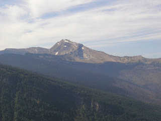
 I like the colors in this one.


 I like the way the foreground and the background have such different colors.
 Up at Logan pass.
 Somehow the trees find life in the rocks!
 You can see the road cut into the hillside.

 One of the many waterfalls in the park.
 This is a shot of the park looking west from the east entrance.


 This is the Two Medicine River
 Two Medicine Lake looking west into the park.
 Looking back at the park from the plains of Montana.
 Another shot of the park from the plains of Montana.
 And, a parting shot of the peaks of Glacier National Park. What an amazing place. As always, the photos don't tell half the story and cannot capture the scale of what you find there.
Today’s story will pretty much be told in pictures. I left Kalispell a little after sunrise and headed north towards the western entry point to Glacier National Park. The departure from Kalispell is pretty neat because you get to watch the sun rise over the Swan Range of mountains. A few miles out I took a wrong turn in Columbia Falls. There is a road that allows you to see a portion of the park not seen from the main road that runs through and I thought this was it. Part of the reason I wanted to take the road was to see more beauty but also to kill some time until the sun was higher in the sky.
There are three important things about photography; first you need a subject, second you need perspective, third and most important you need light. When taking photographs of landscapes the lighting is provided by the sun and in the mountains you need to be on the same side of the subject as the sun otherwise all you get is a silhouette and none of the colors whose contrasts allow the eye to judge scale. And, while the camera can capture the colors, it really is almost hopeless at capturing scale but it does allow the sharing of beauty. For those of you who have been to New York City, there are valleys in Glacier National Park in which you could fit the entire island of Manhattan, valleys with walls so high that not even the tallest building would be visible outside the valley.
Anyway, back to the wrong turn. Once outside of Columbia Falls the speed limit jumped back up to 70 and I decided the oil needed a little warming up so I rolled on the throttle and brought the needle to an even 80 so as not to attract the attention of the department of revenue generation, otherwise known as police. I was tooling along happily, looking at the scenery unfold, passing from lush, forested hillsides to devastated, burned out hillsides. I had read the night before that the fire that burned this section of forest came through in 2001 and up until now the hillsides were still bare of trees. I wanted to stop and get a good look closer to the ground and see if there were any little trees taking the place of the charred remains that now stood.
Deep in contemplation I saw a sign that warned of a speed zone up ahead. In Montana that means that you are entering either a town or a congested area and you will have to slow down. Now, you normally get the warning about a mile before the first sign that will read, for example, 45 MPH Ahead, and then you have about half a mile to get your speed down. In this case, the first sign was about an eight of a mile before the 35 MPH sign and I thought that was strange because there was no town on the map, no intersection and no camp ground. The 35 MPH sign was on a gentle right hand bend and just as I passed the sign I realized why the speed came down. Ten yards past the speed sign was another sign that read Pavement Ends.
Um, the pavement ended about 50 yards past that. When you are traveling at 80+ MPH, the yards tick by pretty quickly so even though your brain can read, register, comprehend and decide in the space of a second, in that time you do cover quite a bit of ground. I hit the brakes hard and then let go in order to get the load off the front wheel and allow the bike to settle before getting on the gravel. There was a good amount of loose gravel on the unpaved road and my eye told me that I would normally not go over about 30 on a straight portion of road like that and I glanced down to see that I would be hitting it at 70 ..... on a curve!
I relaxed my grip on the handle bars and prepared to feel the first sign of a skid so that I would know when I was going down. I looked at the left side of the road which was an embankment strewn with pebbles but at least there were no trees. I hoped that I would go down before that so I could at least slow down before hitting something hard. That way I would walk away with bruises but nothing broken. The bike would probably be destroyed.
I was off the pavement and gently held the bike leaned into the turn with no brakes on and the throttle in a partially closed position – you don’t want to fully close it otherwise you get engine braking on the rear wheel and that will cause the back end to get loose, something I did not want. I picked a path with what looked to be the least amount of loose gravel to the inside of the turn so that I would have as much road as possible to slide across.
The front wheel held on as did the rear and the curve straightened a little. With that I eased way off the throttle and gently started to brake and with a feel for the available traction with that action I fully let go of the throttle and applied more brake pressure. There was another curve to the left coming up and I did not want to enter that with any amount of speed. I managed to stop about half way around that curve.
I stopped right there in the road and waited a moment as my mind caught up to what just happened. I pulled off the road, turned off the motor and decided to wait a bit while watching the river I had just crossed. Everything I just described took place in the space of a few seconds but it took several minutes to play it back in my head.
Well, that was the first surprise of the day and, as with yesterday, my alert level was back to EXTREME. For some strange reason I didn’t get the adrenaline rush and shakes you normally get after a close call. Maybe because I was actually doing stuff through it rather than waiting for what had appeared to be the inevitable.
 This is the scene with which I contemplated that close call.
Oh well, I got the bike turned around with no incident and headed back towards Columbia Falls. While passing through the burned part of the forest I saw a river access road that would allow me to get close to the water. It was a pleasant detour and I walked along the bank for a little looking for a good photo shot but none was available. I was on the west side of the river facing the sun so the camera really would not capture anything.
Back on the bike I soon go back on course and arrived at the gate where I bought my pass. Inside the park I took the initially intended detour which took me ten miles north through more burned forest but gave me the opportunity to whet my appetite for what awaited me in the park. Along the road I got glimpses of the many peaks that decorate this part of the park. This time, when the pavement ran out I was down to first gear about a hundred yards from the end of the pavement and turned around without my wheels touching even one pebble in the gravel.
Back on track I stopped at the visitor center on the west end of Lake McDonald, turned onto Going To The Sun Road and got my first good shot. The road travels along the southern shore of the lake before climbing out of the valley, over Logan Pass at 6,646 feet in elevation on the continental divide before descending to Lake Saint Maries on the east. Below are the photos I took. I don’t know the names of the peaks or the valleys. I will let the photos tell the story and here or there I may add a caption that tells why I liked that shot. My travel agent Michelle recommended this park to me and boy, am I glad she did. She is the best and I would recommend her to all who are reading this. The link to here website is in the menu on the right at the top of the page.
 This was my first view of the peaks in the park.
 The peaks peeking over the trees. You can see what having the sun on the "wrong side" does to landscape shots.
 A display on the fires that ravage the area. Most are started by lightening
 Looking east into the park across Lake McDonald


 Looking up a stream bed to the rocks over Logan Pass.
 My favorite photo of the stream feeding Lake McDonald


 I liked this shot of the outline of the mountains and the trees in the foreground.

 This is the valley and the stream that feeds Lake McDonald.
 In this shot you can see the foreground in recovery from a fire in the 60's, the middle ground is lush forest and the background is still devastated from the 2001 fire. It takes a very long time for forests to recover from fire!
 I like the colors in this one.


 I like the way the foreground and the background have such different colors.
 Up at Logan pass.
At Logan pass I saw a little Honda 125cc enduro motorcycle with an Arkansas license plate! There was a true king of the road! To travel this far on a motorcycle is one thing but to do it on a motorcycle made for trail running in your back woods is another. I saw the guy and he was keeping to himself so I did not bother him and we leapfrogged each other down the road as each stopped to take pictures and take in the views. That guy amazed the hell out of me. It is true you can tour on anything as long as you have the will and the machine. When it tugs at you it is hard to resist the call of the road when it comes!
 Somehow the trees find life in the rocks!
 You can see the road cut into the hillside.
 That is a smile of stunned amazement at the beauty of this place.

 One of the many waterfalls in the park.
 This has been a particularly hot and dry summer so there is less snow on the mountains than normal.
 This, like all the other valleys here is shaped by a glacier. The difference between a glacier formed valley and a river formed valley is a glacial valley is "U" shaped as is well seen here while a river valley is "V" shaped.
 Yeah, I like rocks up against the blue sky!
 This is a shot of the park looking west from the east entrance.
 Peaks rimming Saint Mary Lake looking west.
 A slightly different view of the same shot.
 A little further down the road looking east on Lake Saint Mary.
 A parting shot of Lake Saint Mary.
On leaving the park I made took route 49 at Kiowa which would take me to another access point in the park. I was not disappointed! I had to pull over to unload the camera into the laptop as I had filled the memory card and I was glad I did because I got the following shots in this section.


 This is the Two Medicine River
 Two Medicine Lake looking west into the park.
 Looking back at the park from the plains of Montana.
 Another shot of the park from the plains of Montana.
 And, a parting shot of the peaks of Glacier National Park. What an amazing place. As always, the photos don't tell half the story and cannot capture the scale of what you find there.
After that I headed for Great Falls where I was to spend the night. It was about a 150 mile ride and I had to pick between the freeway and back roads. To this point the road was twisty and the vegetation was not cut back. I had happened across cows both on the road and on the side of the road since leaving the park and this did not allow for full enjoyment of the roads because there is no way I was going into a corner hard – especially not after having to brake hard for five cows that seemed to be contemplating the meaning of life in the middle of one particularly sweet left hander.
The terrain quickly turned flat. Not as flat as Kansas but a hell of a lot more featureless!! Wheat fields, miles upon miles upon miles upon miles!! Every once in a while there was some pasture dotted with a few cows but otherwise it was just fields of wheat! Even trees were scarce and the only ones to be seen were those that were next to the occasional house. If you don’t like having neighbors close by, this is the place to be. Oh, you can see your neighbor’s house only it is about five miles away!
With the wide open spaces and no place for a cop to hide I decided to make quick work of the trip to Great Falls. Rather than take the initially intended back road and risk more encounters with open range stock or other large beasts I headed for the freeway. Let’s just say that it took way less than two hours to cover the distance and a tank of gas that would normally last 250+ miles was burned through in about 150 miles and leave it there.
About five miles outside of Great Falls I hit the rain I had been watching for the last half hour. I wondered when the clear skies would end and now my question was answered. Funny thing about it was the forecast had called for 0% chance of rain. Weathermen!!
The rain must have been torrential before I got in because the streets were flooded! I found my hotel and the rain stopped as I finished unloading the bike. There was a Mexican restaurant within walking distance so I strolled over for a good filling meal washed down with a tasty Corona.
Back in the hotel room I decided to check the weather for tomorrow and all along the route they are calling for cloudy skies with 60% chance of rain in the morning and thunder storms in the afternoon. Looks like a wet day on the road!
Subscribe to:
Comments (Atom)