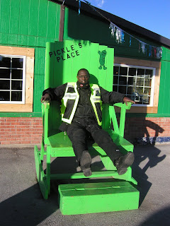
There is normally something about each town that strikes you and the one thing that was interesting in Idaho Falls was the guy manning the counter in the evening as well as the one in the morning and the cashier at the gas station just up the road were extraordinarily articulate and particularly well spoken and full of cheer. They must have an excellent education system because there are few places you will find even university graduates who have such a command of the English language.
Though I was in early, I really didn’t feel like working on the blog so I just chilled out and rested in the hotel room after gassing up the bike and scouting about for a place to eat. I settled on Applebee’s as it was the closest plus I got 10% off if I showed them my hotel card key.
I was up and at them bright and early and I got to enjoy watching the sun rise over the Grand Teton peak as I rode west along route 20. That has got to be the straightest road I have ever ridden! It points west and you get the occasional one degree turn. Well, there really is not anything to go around so there would be no need to have corners. No farms, no dwellings, no rivers, no hills, nothing!
While the plain was, well, rather plain, it is rimmed by beautiful mountains on all sides so you can’t really be bothered with the desolation. Before getting to Arco you ride through tens of thousands of acres of land the Department of Energy uses for some sort of research. There are roads here and there and each is marked with a large sign informing would-be adventurers that they would be entering a restricted area if they proceeded further. I saw a couple of buttes and stopped to take a photo of only one because I was afraid of getting in trouble for taking a photo of a restricted area.
 This is one of the buttes in the restricted area looking south off route 20. You can see that fire damaged the plant life here.

Arco, Idaho is a town truly in the middle of nowhere! The population is about 300 and some which is better than the town before, Butte City which boasted a population of 79! I stopped at what appeared to be the happening place in town for a hearty breakfast before heading north into the Bitterroot Mountains.
 These are some hill just east of Arco, Idaho.

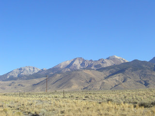
From Arco the road follows the Big Lost River until Borah Peak in the Lost River Mountain Range which at 12,662 feet in elevation is the highest point in Idaho. It is a beautiful range of mountains and it provided captivating scenery for the drive into Challis.


 Borah Peak, the highest point in Idaho.


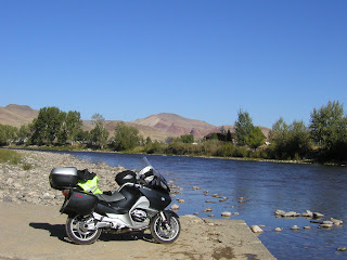
Just outside of Challis I pulled off on a river access road to the Salmon River. A shallow pebble bedded sparkling and clear beauty. I took the bike all the way to the bottom of the boat ramp as that seemed like a great place to stop and pull off the layers. The day had started in the low 50’s but the temperatures were now in the mid 80’s. It was a good little break and it gave me a chance to let the coffee from breakfast out. The facility here did not sport the flies of the Togwotee look-out so no sprinkle the fly today :(

 A beautiful day on the Salmon River.

From Challis the road hugs the Salmon River all the way through Salmon to the Lost Trail Pass in the Bitterroot Mountains on the Montana border. This road was a sheer delight to ride. The speed limit was 65 and the locals were moving along at 75+ so, when in Rome ...... With the light shimmering off the Salmon River, alternating grassy hills, sheer multi-colored rock cliffs, sparsely forested slopes on either side of the river and smooth clean pavement with tight sweeping turns I let the bike breath good long and deep. What a thrilling ride!!
I stopped in Salmon to gas up and put a layer back on for the climb up to Lost Trail Pass. I did not want to have to stop on the climb as there are sometimes no safe places to pull over. That is one of the things about riding the mountains – the valleys are stiflingly hot but the passes are pretty darned cool so you either dress for the valleys and freeze going over the top or dress for the top and roast in the valleys. Being a freeze baby I chose to roast. And roast I did because the today the temperatures did not let up as I climbed. Oh well!!
Crossing into Montana the speed limit was still 65 but the locals were moving along at 75 – 80 (once they were off the mountain pass) so I happily kept up with them.
You hear about forest fires on the news but until you have seen the devastation they cause you cannot even begin to appreciate them. Dropping down into the Rock River valley the slopes on either side had been razed bare and it really looked like a bomb had been dropped. Coming up the Idaho side of the pass I rode through lush green forest and had been looking forward to the same in Montana.
The other thing about forest fires is the smell. As you ride through the devastated area you smell ashes infused with a sweet citrus scent of a cedar chest. The impact it has on you the first time you go through it is interesting and the scale of the damage is incomprehensible. I rounded a corner and saw a field that was probably a good 100 acres dotted with tents and campers. I though it was a strange place for a camp ground but it turned out to be the Incident Camp for fire fighters who were doing battle up in the hills. There were hundreds of tents, catering trucks and what has to be the largest amount of Gatorade I have seen in one place.
I was hoping for some good photos but the bare hills were too sad to capture so I just let them settle in my memory. Looking ahead it seemed really really hazy which I though was strange because it was not humid plus there are no large bodies of water in the area.
I soon picked up the smell of smoke. For the next 100 miles or so the scenery was obscured by the smoke of the fires. I could see the silhouettes of mountains on either side of the valley, beautiful mountains but I knew that as faint as they were through the smoke, the camera would never capture them so I rode on. I did take one photo of Trapper Peak at an elevation of 10,157 feet and, as you can see in the photo, you can barely make out the mountain in the background!
It was like riding along a huge camp fire. Smoke, smoke, smoke! There was one stretch of road where the signage warned of a ticket if you were caught driving with no light for the next 30 miles!

The smoke had let up when I arrived in Lolo where I stopped for a short break, gassed up and hit the head. A local group of riders pulled in to gas up before heading out for their ride. One of them over filled his tank and a good quart spilled out of the overflow tube as he pulled from the pump to the spot next to me. Good thing I was getting ready to go because one of them was about to light up a smoke!
I go on route 12 for the ride back across the Bitterroot range into Idaho. I had about 30 miles to ride in Montana and the speed limit on this stretch of road was 70!! On a two lane road up a mountain pass – pure heaven!! With little traffic to bother me I let her rip and the only thing that did not allow the throttle to go wide open was the occasional moose crossing warning. These were no mere yellow diamond signs with a silhouette of a moose. No, they were huge signs plus MOOSE XING warning painted on the road. I brought the bike down to 25 as I passed through those! The thought of meeting one of those beasts was terrifying.
In short order I was back in Idaho. Talk about a cold shower. On the Idaho side the speed limit was 50!!! Descending off the Lolo pass that was not too bad because the turns are very tight and you really cannot do much more than 50. When it opened up to sweepers the speed limit was downright frustrating.
The road follows the Lochsa River all the way to the Washington border. I only rode 150 of those miles today leaving the remainder for tomorrow. After I got over the speed restriction I settled into enjoying the river valley, a lush and heavily forested valley providing a backdrop to the beautiful river. It was beautiful but after about 30 miles it seemed that you were having deja vu because it all started to look the same. I could have sworn I saw that curve twenty miles back.
It really is a beautiful valley and every now and then there were people fly fishing, children skipping stones, hikers preparing or returning from romps in the forest. What a blessing for those who live here to have this beauty in the back yard. As I drove along I appreciated why the limit was set so low; there were campers all over the place, not that it was one huge camp ground, but there was a good enough number of them that popping around a corner at 80 miles an hour and happening upon one pulling out of a camp onto the road would rapidly become a sticky situation for the approaching vehicle.
At Kooskia I turned south on route 13 for the 30 mile ride into Grangeville. Just outside of town there was a ten-mile stretch of switchbacks that were wonderful to ride. I have to go back that way tomorrow as I head north and I am looking forward to that as the start of my day!
I had no problem finding my hotel and checked in to what has got to be the cleanest hotel I have ever stayed in!! This place is absolutely spotless, the staff was friendly and helpful and there was a steak house within five minutes walk. I unloaded the bike, took it down to the gas station to fill up, came back to the hotel and settled into one of the Lazy Boy recliners to look at my photos and work on this blog.

2 comments:
Awesome trip and a very cool blog. I found it doing some research for a trip to climb Mt. Borah this summer.
Can I use your photo of Borah Peak in our trip planning blog -- it'll give the guys something to focus on while we train?
Chris, thank you very much for taking a look at the blog. I am very flattered that you would like to use it for planning purposes!! You absolutely may use any of the photos you would like for your planning!! Again, thank you for taking a look, enjoy your trip and be safe out there. When I drove through the area was being ravaged by terrible forest fires. Hopefully they burned themselves out and you will have clear and open Montana skies!!
Post a Comment